September 2022 Climate Forecasts Meets Poetry: A Unique and Inspiring Combination
Experience the Climate Crisis through the Creative Lens of Poetry and Weather Forecasts

Currently is a weather service for the era of climate change
Currently is a free subscription weather service — delivering daily weather poetry to your inbox, and connecting you with interactive weather alerts and real-time climate context straight to your phone. We’re a community of people sharing resources and delivering justice, hope, safety, and resilience in a world in urgent need of systemic action.

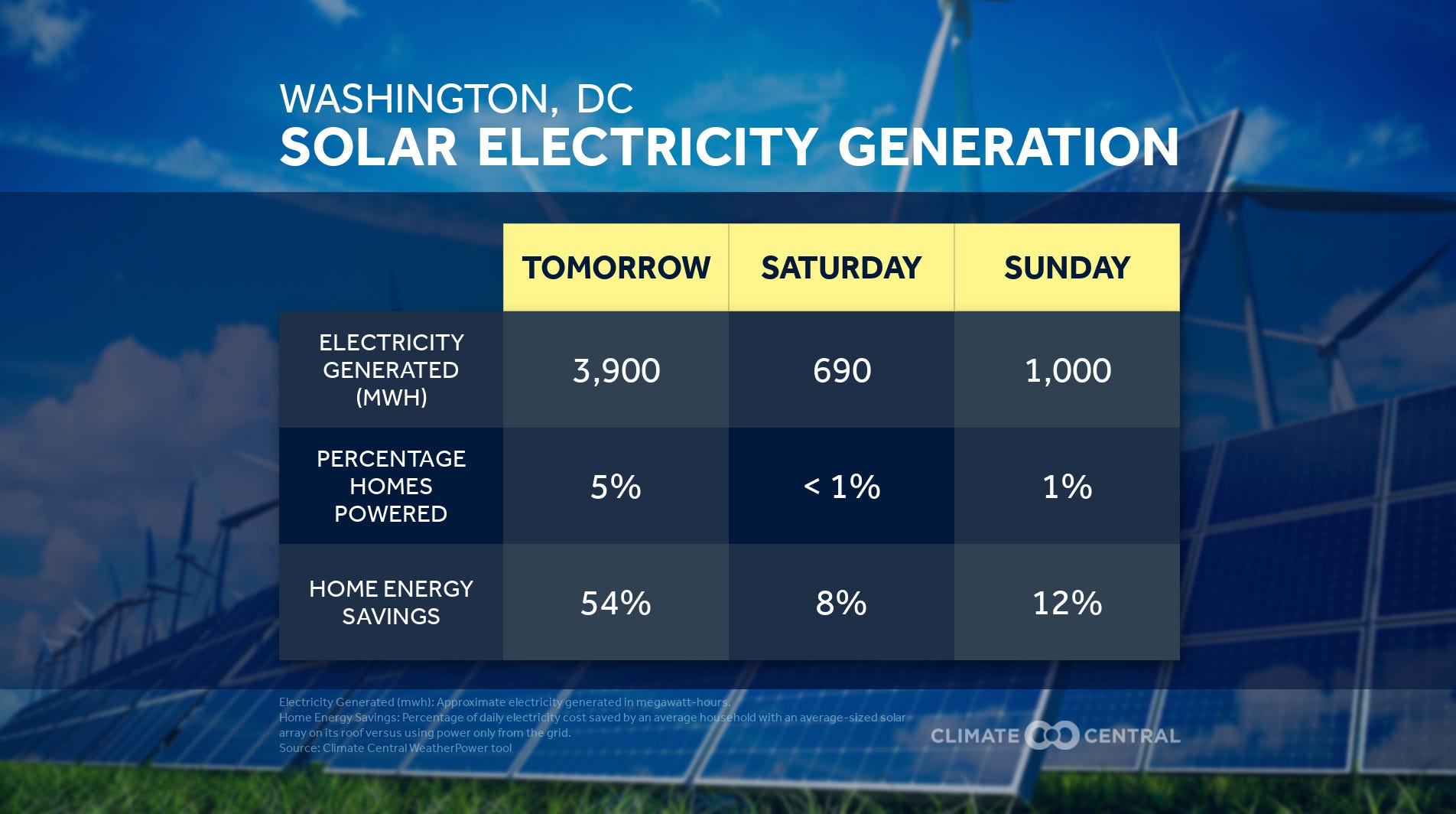
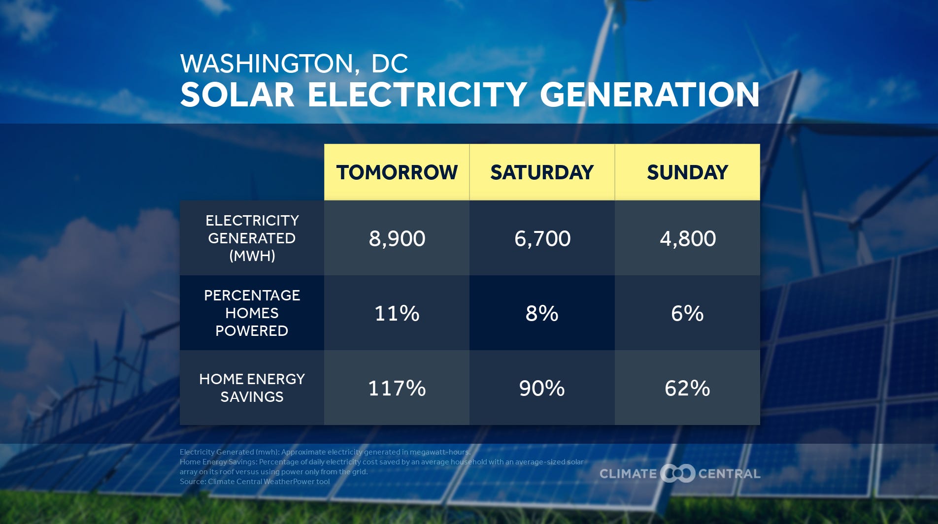
☀️🧢🚴🏿♀️🌳🌞 Thursday: DC’s abundantly sunny & clear. ~10,000 MWHs solar bright. Slightly hotter than yesterday but relatively low humidity. High pressure keeps rain away, swept with a light breeze. Gorgeous for a morning bike ride. Great for an after-work crop top.
What happens when DC neighbors band together & transform a section of asphalt in their own backyard?
DC region leaders want to halve transportation emissions by 2030 despite road widening plans
From Kyle Carrero Lopez’s incendiary poem, “Ode to the Crop Top”:
“Why you in a girl’s top,
the man yells in DC.
I could have cut him one too,
so we’d both feel the breeze.”

LABOR GRACE SONNET
☀️🚴🏿♀️🌳🌤
Friday saunters sunny early morning
with mostly moderate humidity
throughout becoming cloudy in warming
skies, gentle breezes flapping flippantly.
🌤🍄⛅🌘
Saturday sashays partly cloudy-veiled,
giving a gray glamour getting hotter;
Afternoon works-it more humid-trailed,
highs near-90°F feeling air’s moisture.
⛅🛴☁️🌧️
Sunday scurries cumulus-overcast,
over fast-building moisture to Monday;
where Sunday’s storm chances stray & don't last,
Monday’s look sporadic, & later-day.
✊⚒️️🙏🧰
May it wash & nourish all your labor,
For all the weatherers & the workers.


☁️🐦🌂🌧️☂️ CHIRPING YES SONNET
What’s up, Wednesday? Clouds, yes. Comfortable
warmth, yes. Upper-70s°F highs, yes.
Light shower chances, yes. With multiple
AM scattered pitter patters, yes. Less-
so by PM, but showers could steady,
yes. High humidity, yes. Wet’s the word,
yes. Best with umbrellas at the ready,
yes. Sounds like flapping air gathering turns
in migrating birds, turning the response,
finding moments of warmth in: the journey,
sky scents, the cloud-veiling waxing gibbous,
and the flock–each other– no matter how stormy;
like birdsong beckoning dawn, each day’s blessed,
in ultrasonic tenderness, sounds like: yes.


⛅🥁🗣️📣☁️ Thursday, DC is giving: opalescence in mixed sun+cloud skies with a slick slight chance of rain showers. Light rises a kind of will-they-or-won’t-they sun-threaded slightly-warmer weather which energizes your march onward— no matter what. For climate justice. Like Thursday’s No More Sacrifice Zones rally/protest/event. It’ll get humid through afternoon, but so be it. Sweat fierceness. Following Appalachian Resistance, fight for life— into the 70s°F-sunset. For the same sunlight setting we share to rest softly over safe homes. To not be sacrificed— show up for front lines, echoing No More Sacrifice Zones. Find a place to do your part. In Resistance. For Appalachia, The Gulf Coast, North Alaska, for fossil-freedom everywhere for everyone. We say: No More Sacrifice Zones.

What you need to know, currently.
Anti-pipeline activists will converge in Washington D.C. this Thursday in an effort to convince lawmakers to halt the Mountain Valley Pipeline — a pet project of Senator Joe Manchin, that was revived as part of the deal brokered to pass the Inflation Reduction Act.
The methane pipeline would cross 303 miles of mountainous, landslide-prone terrain and pass through several areas where a potential accident could severely affect residents’ drinking water. Landslides are a relatively common cause of pipeline explosions in Appalachia and building regulations are lax.
"No one is really saying, ‘We’ve looked at this and this line is safe,’" Rick Kuprewicz, a chemical engineer who worked on pipelines before going into safety consulting, told E&E News in 2019. "The system favors rushing."
Click here to tell your representatives to block the Mountain Valley Pipeline

🌞🚴🏽♀️🐦🌾🌕 RENEWABLE HARVEST MOON SONNET
Gather Friday's sunshine in abundance.
Gorgeous sunny skies, mid-80s°F highs,
& moderate humidity— wondrous
into the clear late-Summer evening sky
will fill you with a renewable glow.
The harvest moon — both lunar punks’
& poets’ muse— emcees the weekend flow
into Saturday, part clouds & part sun,
while Sunday wanes cloudier, muggier,
& with periodic showers chances.
Though the weekend’s skies end muddier,
there’s clarity in nature’s extravagances:
moonshine, sunshine, starshine -harvesting,
for you, I’d reap each sky beam sparkling.


☁️🌂🌧️☂️⛈️
Monday’s cloudy ruffles dampen, drip, & shock.
Puffy makings of mist fill morning skies. So even
if your day starts dry as you ride-out, umbrella-
& rainfrock-up. Because later, incoming cold-
front layers of wet air & pressure mix showers
into possible thunderstorms into warm late-
afternoon into evening commutes & wet likely
into night. The National Weather Service
(NWS) has flood safety guidance, advisories,
& forecast data for near-term weather. & as of
last week, the Biden Admin has new tools for
anyone to project local scenario impacts like
flooding, for our future climate: Climate
Mapping for Resilience & Adaptation
(CMRA) portal @ resilience.climate.gov


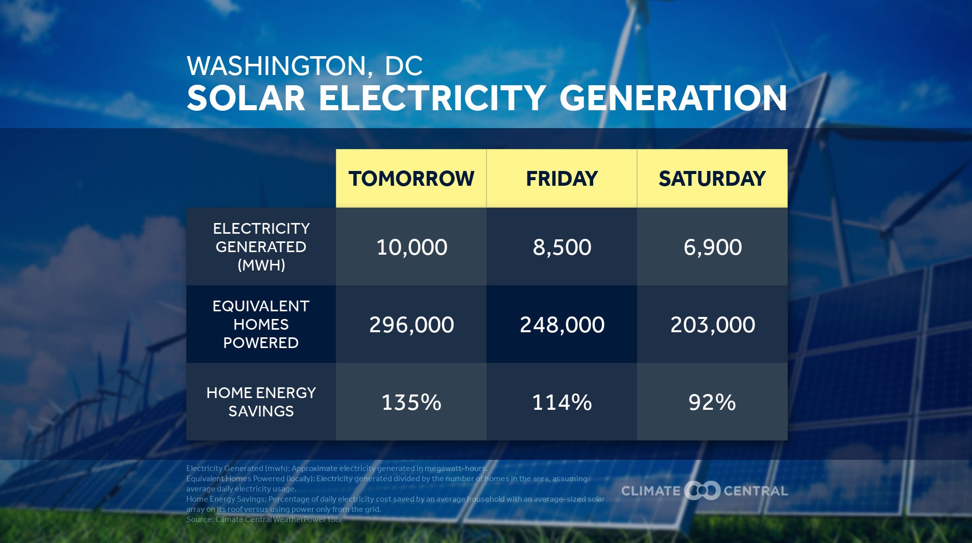
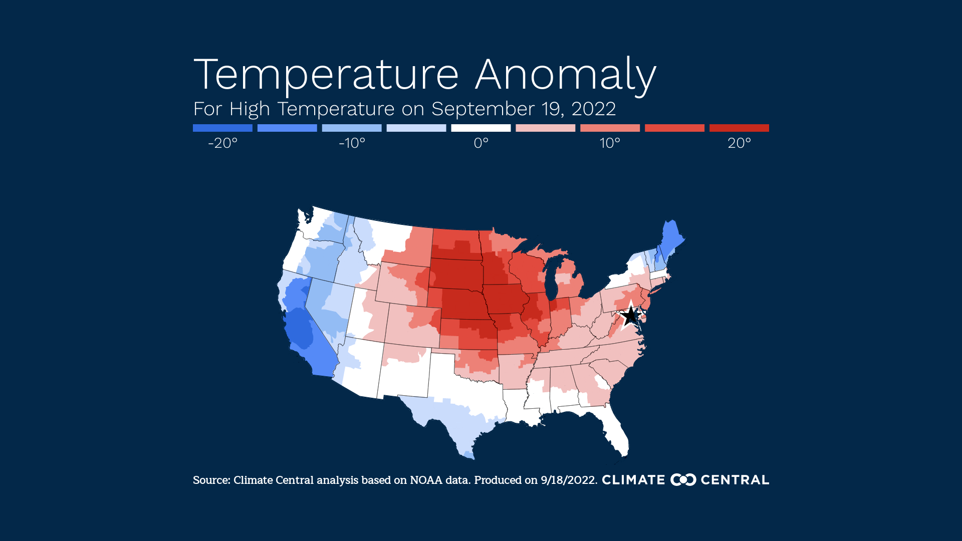
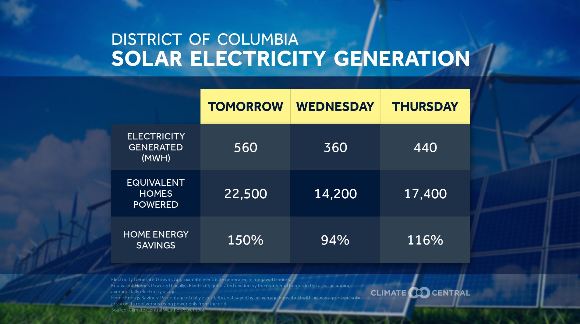
A Clearin’s A Comin. Through Tuesday morning’s clouds, breezes bring refreshingly cooler air to you: not only dropping temperatures by degrees— with highs topping-off in the low-80s°F & a low of 60°F, but also— dropping humidity and dew points by bands, with airier breathing skies. Change abounds, but there’s still a small chance a lingering shower sprinkles as DC’s weather turns. And once the turn’s complete, enjoy. Ride, organize, get outside, and just breathe. We should shine these 7k+ Megawatt hour solar skies for the rest of the week.


☀️🚲🌳🚇🌇 Hello sunshine— clear skies,
morning light and airy, and morninglight
will tip their hats from dawn’s shawl-brisk-
breeze, towards your 80°F-high afternoon
they breathe. Breathe it in, understanding
there is no more grandness I can grant you
than what you get from even just a moment
in it. Within, a slight northwest wind extends
your smile like some emissionless microgrid
distributing joy and life and power even into
evening— clear still, though not even an end;
giving, grand continuance beyond Wednesday.


☀️😎🚴🏼🐿️🌻 Sunny threads spread-smooth and knit breezy nets across DC Thursday. Another sun-drenched day in this run well-worth you getting-out for a breather or break for some fun. Morning’s fresh air will cool lows into the high-50s°F, giving crispness in these last late edges of Summer. Meaning, comfort comes in your light hoodies out early, shrinking by warm afternoon into short sleeves.
Better yet, Friday's looking just as solar-sational & sun-splattered— a few degrees warmer. A sunny spectacular Friday for DC’s annual Park(ing) Day, where you can enjoy meeting up at paved parking spaces turned recreational areas on your commute and throughout the day, 9am-6pm.


Ode to Park(ing) Day
☀️🌳🚴🏼🐿️🌻
O ray of sun, rise over the curbside
commuter oases Friday in the lush
green pop-up parklet let's meet-up
which one? all! map & pathway here
breeze easy horizons clear as you're
cycling from your place & I'll either
metro/bus-it & meet in the middle
after noon's warmth on a light wind
skies bright in eyes let’s meet again
when we meet again, O transformation—
bring us back to the roots of the day: pro-
test, giving, actual poetic justice, not just
gestures at directions like pandemic-
inspired open streetways now closing
though needs are only always growing
for community & joy & healthy spaces
joining each campaign for a livable DC
to be self-determined & free, like weekend
sun-lit & solar-kissed; to rest & persist.
What you need to know, currently.
We've had an unusually quiet hurricane season this year, but the National Hurricane Center (NHC) issued a warning today for Tropical Storm Fiona. "Heavy rains from Fiona will reach the northern Leeward Islands Friday afternoon, spreading to the British and U.S. Virgin Islands and Puerto Rico Saturday into Sunday morning," said the NHC. "This rainfall may produce flash and urban flooding, along with isolated mudslides in areas of higher terrain. Considerable flood impacts are possible across eastern portions of Puerto Rico."
Fiona is expected to pass by just as Puerto Rico marks the five year anniversary of Hurricane Maria. Maria made landfall on September 20th, 2017 as a devastating Category 4 storm and the archipelago still has not fully recovered. Maria caused the longest blackout in United States history and was responsible for at least 3,000 deaths — many of them resulting from the 11-month-long blackout.
Rolling blackouts remain an issue even when the weather is good. Puerto Rico's embattled electrical grid relies heavily on imported oil and gas and substantial upgrades and repairs have been put off for years. “Until they rebuild the grid, these blackouts aren’t going to stop,” Federico de Jesús, a political consultant and adviser for the advocacy group Power 4 Puerto Rico told The American Prospect last month. “They could get marginally better, but it’s a systemic failure.”

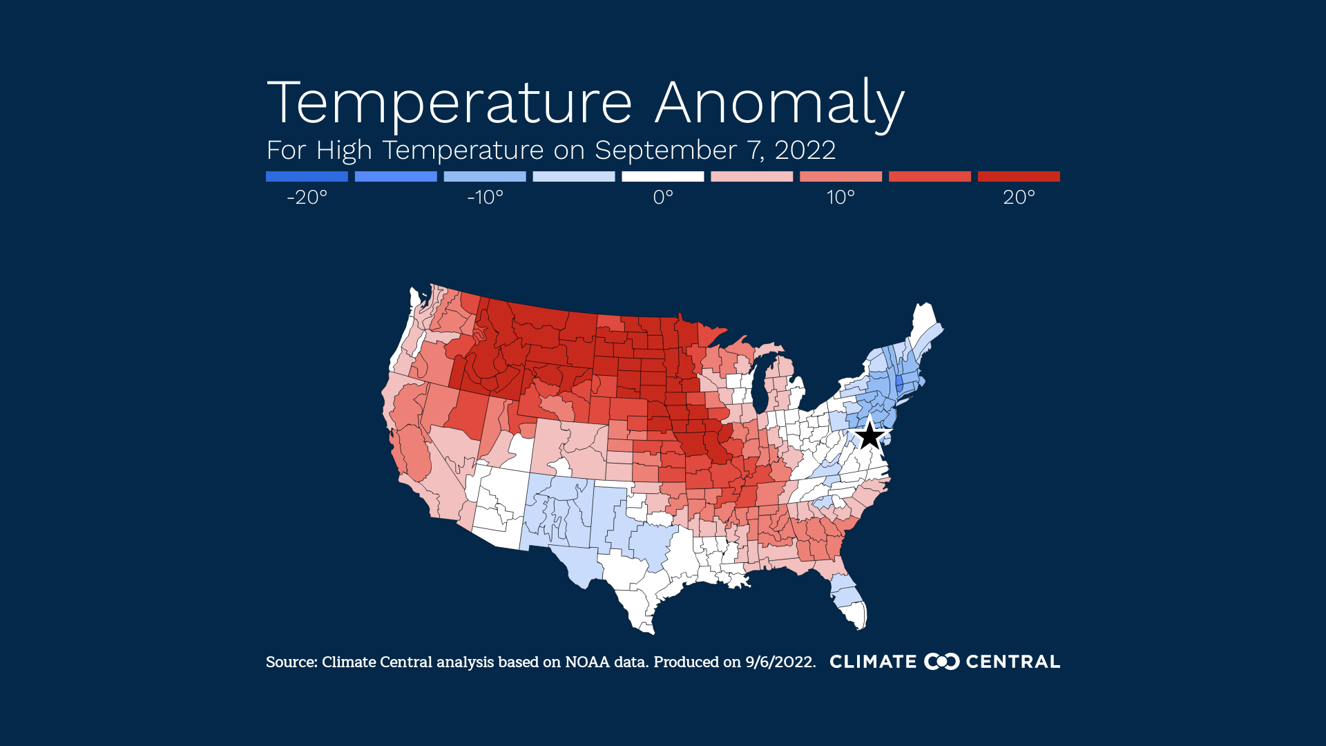
☀️🌇 DC’s Summer is not settled yet— at least, not in this fossil-fueled climate. Beginning Monday, temperature highs amble anomalously warm: 10-degrees Fahrenheit above average. Under an amber sun, slight Southwest breezes breathe, brushing still verdant canopies framing fairly clear skies.
🌤🥵 Monday-Midday-to-Evening: highs near 90°F. Feeling warmer with the same sunglare carrying slightly-more-humid over sweat-pricks into midweek; cooled by airy dawns, settling dusks, & graceful breezes. We can’t rule out all that warmth & moisture may mix into more cloudage & possible showers, however slight the chances.
🌘🍂 Expect Autumn’s Equinox– upcoming Thursday– to break this heatspell; attempting to bind the season’s power back crisp, in brisk-er temperatures.


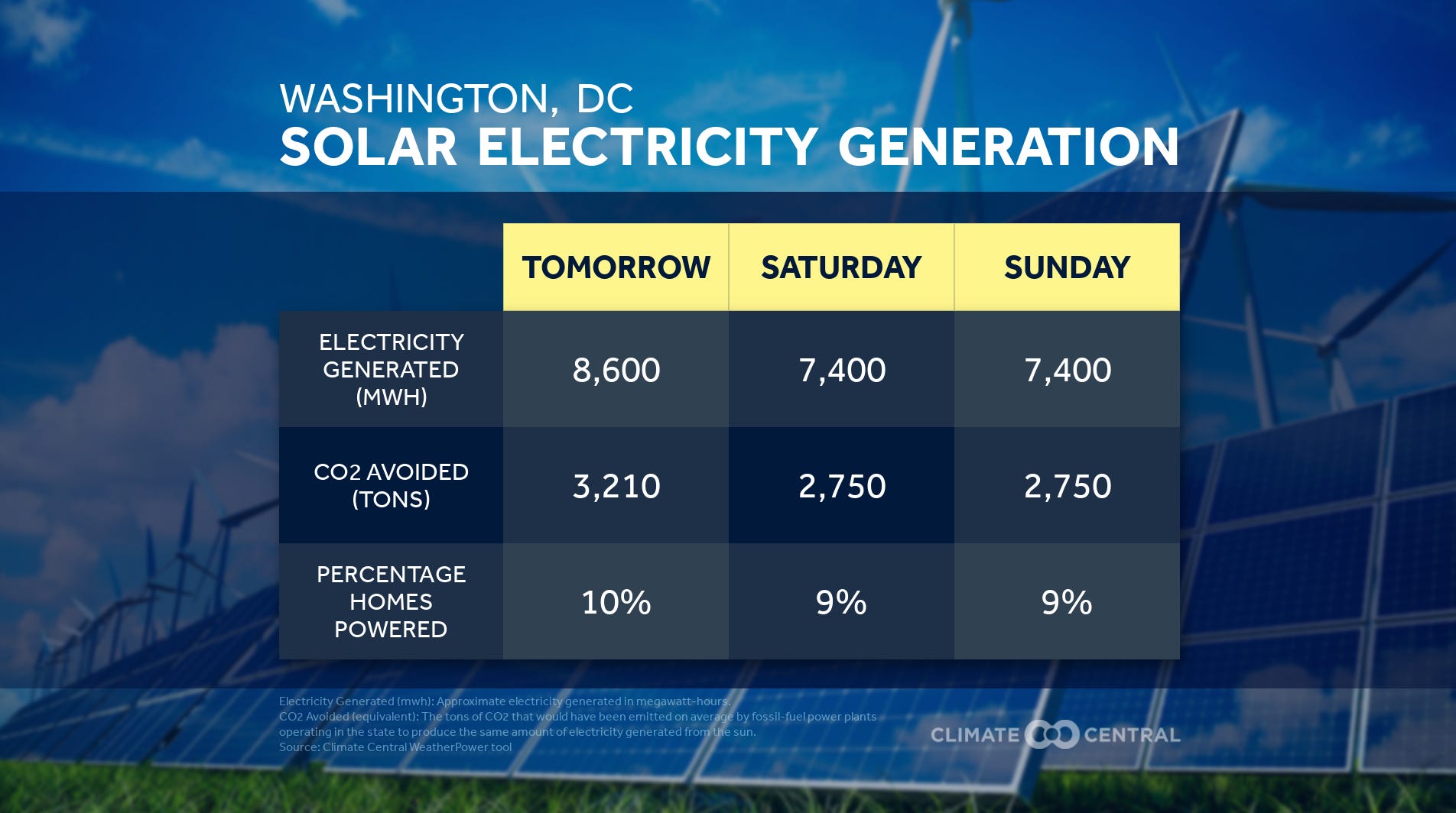
☀️🚲🌳😎🌞 Expect a pretty Tuesday, as in — pretty beautiful & calm sunny bike-riding weather. Solar-powered to the 8,800th Megawatt hour. Tuesday’s out & active early, blood pumping steadily to warm through the earlier cool-ish dawn, & then later short-sleeved in afternoon highs up to the mid-80s°F (not one to be outdone, Wednesday is preparing to take you degrees hotter). Until then, these serene Tuesday vibes fly in a light Northwest wind, murmuring a calm verdant shake through trees.


🌤 Wednesday is: warmth-wrapt, sun-backed, bloom-baked, & breeze-draped. 🐦 Birdsong rises with that all at dawn's caper. ⛅ It sings your horizon like a golden oldie Summer hit— hitting hotter than yesterday for sure. 🌇 A classic, that will play again, someday, so PM hours don’t have to hold so tight on to heat like this is the last dance. 🪩 Bringing airy warmth into evening fancy with cloudy skyscapes & shower chances. 🌧️ Come Thursday, The Turn— your invigorating Equinox. 🌘


⛅ Thursday throws a tantrum before Friday’s Fall-feels. 🌬️ A cold front late-morning Thursday is expected to gust winds dragging temperatures degrees-downwards from the start of this week into your weekend. ☁️ Watch out for all this scattered energetic air giving blustery gusts turning to blasts of rain & maybe even thunderstorms. 🌧️ It’s likely you’ll see some clearing by Thursday evening, giving Equinox-spiced latte. 🌘
Riffing on a feminist reread of that ol' climate-changing myth, an Ode:
Equinox Evening Ode
O dusklight of the Equinox,
make our myths more obvious
than this— cast out the violent
supremacists, Hades & Zeus,
transform subjugation & abuse
& give Demeter & Persephone
everything to repair & reroot
eternal reunions of love & legacy.


Friday ☀️ Sun-drenched hoodie weather. 🌬️ Winds could zip & zephyr, at times gust & maybe squall. With the switch to such cool 40s°F lows & upper-60s°F highs, feels like Fall. 🍂
Saturday ☀️ Bright skies with slightly higher highs in the mid-70s°F. 🚲 A brimming briskness threads through beautiful airways for another refreshing afternoon outdoors. 🐦
Sunday ⛈️ Warmth should creep up even-more to an 80°F high. 🌳 But watch for an incoming storm system that could produce periods of rain & possible thunderstorms. ☂️

☀️🏃🏿♀️🍃💨🌤WIND(Y) & SOLAR AUTUMN SONNET
Monday’s forecast is part wind & solar.
Sunny & breezy. Airy & breathing. Skies
find you Afternoon opulent with warmth,
still a bit of a gust, & Autumn vibes.
Chic weak-greens & sleek olives pockmark parks
& sidewalks along your morning jog-way.
Winds flit such conversational Fall-talk
they begin to reveal magic layers
of cool. That old trick: how thick, if any,
should the layer you’ll end up carrying/
not-wearing be? See, don’t worry. Heavy
is the head dwelling the world worrying.
Instead— be your own renewable dream.
Hold it all together in a sunbeam.


🌤🌳🚲🐦 🌄 Tuesday’s cooler, though still comfortable. With thankfully mainly sun expected. Morning manages a warm-up with maybe a couple clouds pulling-up. Midday, highs reach mid-to-low 70s°F, so calibrate your style to what’s giving, homeostasis— with 20-degree temp ranges through these days. Evening rides a light cool front, bringing cool cool cool near-40s°F lows.
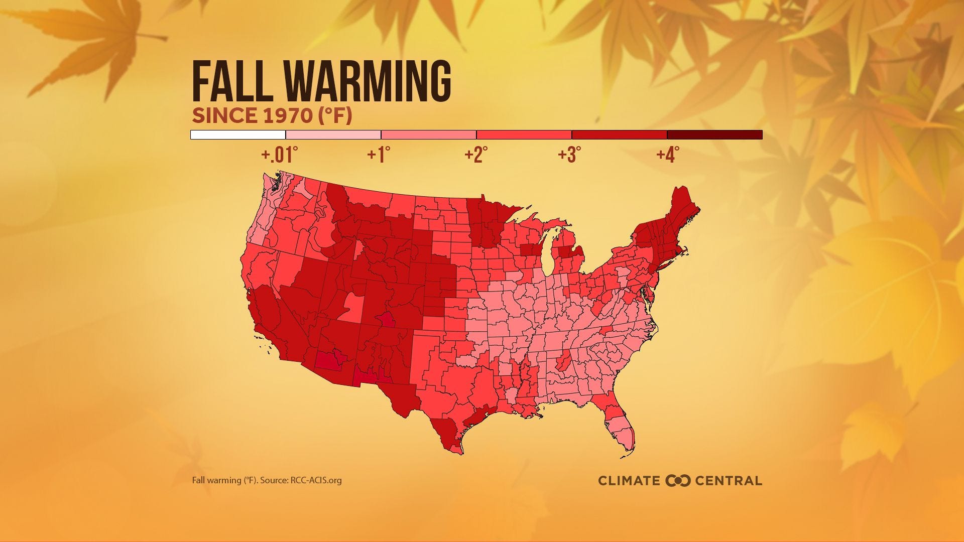
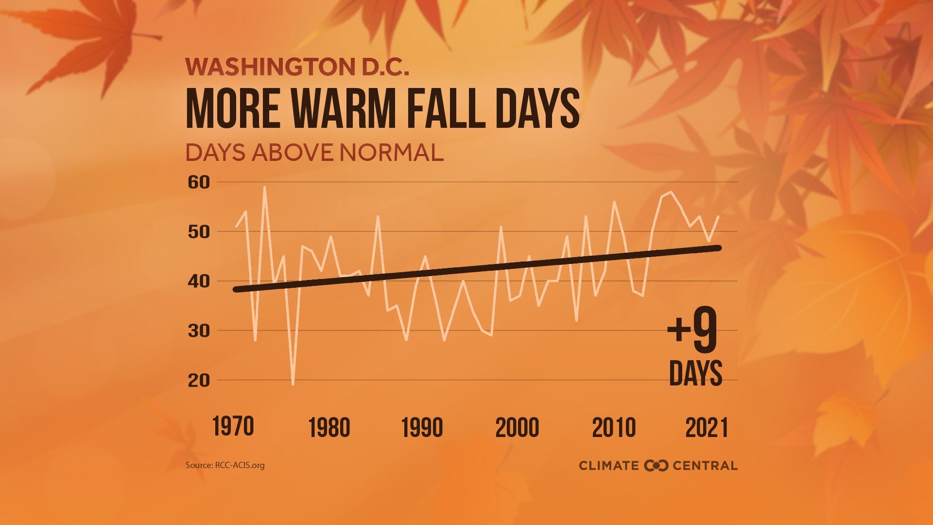
For all you cool cats & climate communicators— here’s both a Summer ‘22 In Review & a Fall ‘22 Package of localized data & chart resources from Climate Central to engage your communities. Helping everyone understand global warmth in-movement to highlight this critical moment: to act on climate & save all we can— including the pleasures of Autumn.

🌤🚴⛅ A quaintly pleasant Wednesday rustles out from the dark-violet horizon over a chill dawn. Getting brighter and sunnier with Morning blood-pumping, biking against light winds. Both commutes should blow-by as easy as the breeze.
Afternoon finally finds that moment to stop what they’re doing, step-out, bask in the mostly-sunny & 70°F-high, & smile. Keeping partly cloudy into Evening; BUT with enough silver linings to sew someone a cardigan. Instead— for you, I’ll pull out just one shiny thread: EPA’s new Office of Environmental Justice.
OK, so— here’s even more shine we can weave:


☀️🌳🌤🐦⛅ ODE TO NEW DAWNS
After "Marking a Win for Frontline Communities, Manchin Withdraws Dirty Deal from Senate Vote"
To you airy early morning. Carrying forward wins of yesterday. To the sun that rises from you. Frontline Fighters, Supporting Organizers, Justice-Doers. To you who brighten inside. Those who hold solar 70s°F afternoon highs all the time. All voices continuously gathering, like Thursday’s winds from the North. The ritual expectation-shattering making possible another world. To the climb— like hyacinth vine, from each average Autumn day’s cool, twenty degrees warmer past noon, & then back down to dusk. You pleasant days who know we must: stay organized to stand with & up for the most marginalized to decarbonize. Keeping onward with each win. To you whose new dawns rise, again & again.

☁️🌂🌧️☂️ Friday— opalescent clouding skies are expected. It’s all connected: to remnants from Ian atmosphering into overcast air & Weekend showers. I advise getting ready for rain, with unlikely but possible showers starting as early as Friday afternoon, becoming more likely overnight.
Saturday & Sunday— already look like a wash. In what could be all-day scattered showers with periods of lighter patters; so far, DC forecasts haven’t yet raised heavy downfall-to flood-watch warnings. Stay vigilant still, in our fossil-fueled supercharged climate, with forecast changes from the source: